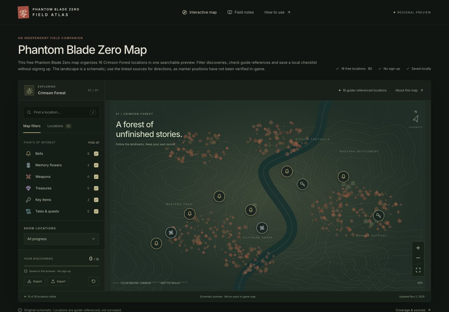
How do I use the Phantom Blade Zero map?
The map is free to use and does not require an account. Open the homepage or the Crimson Forest regional page to use the same collection of sixteen guide-referenced locations. The two pages share your local checklist on this browser. You do not need to upload a save file, connect a gaming account or install an extension.
This is an illustrative regional preview. The drawing is not a measured map of the game, and the positions of the markers are not verified game coordinates. Use a marker to open its note, then follow the source guide when you need detailed directions. This limitation applies even when a location name is familiar.
Search, categories and progress filters
Enter a location name in the search field. Search is case-insensitive and also matches category names and the area labels used by this atlas. You can press the slash key while not typing in another input to focus the search. On mobile, open Filters first or use the same shortcut with an external keyboard.
Map filters contains six independent categories. A checked category is visible; an unchecked category is excluded. Hide all turns every category off, and Show all turns them back on. This changes the view only and does not delete found markers.
The progress selector has three states. All progress includes both completed and incomplete visible entries. Not found yet excludes completed markers. Already found shows only completed ones. Search, categories, progress and spoiler settings work together. If no results appear, reset the filters before assuming the atlas has no relevant entry.
Read a location and record a discovery
Choose a marker or an item in the Locations tab. The detail card shows its category, name, organizational area label, short location note and recorded access requirement. Read the source link for context. The guide reference is evidence for the entry, not proof of a surveyed position.
Choose Mark as found after making your own discovery. The marker changes to a check and the progress bar updates. Select the same location and use Found — undo to reverse an accidental mark. The progress total is sixteen for this preview. It is independent of the game’s own completion display.
When you filter to Not found yet and mark a location complete, its marker disappears from the remaining results. This is expected. The card stays available so that you can undo the action immediately, or you can switch back to All progress to find it later.
How can I recover a saved checklist?
The atlas stores your found-location identifiers in browser local storage. It also records a backup format version, region identifier and update time. The preview does not send this checklist to a server. Local storage belongs to the browser and site address, so a different browser or domain has a separate copy.
Export downloads a JSON backup. Keep that file outside the browser if you want a durable record. You may need it after clearing site data, changing devices or using private browsing. Downloading a backup does not clear your current checklist or change any markers.
Import asks you to select a backup file. The atlas checks its format, region and location identifiers before accepting it. A valid file is merged with the current checklist. Existing found points are preserved, duplicate entries are collapsed, and malformed or incompatible data is rejected with a message.
If the browser blocks storage, the interface warns that the checklist is session-only. Export before leaving. If a saved record cannot be read, the atlas reports the problem rather than pretending it loaded correctly. Reset is separate from import and always opens a confirmation dialog.
Spoilers, sharing and mobile controls
Story locations starts off. This excludes the quest and reward entries that this preview marks as story-sensitive. Turning it on reveals their names and notes. A direct link to a hidden story entry shows a reveal prompt instead of immediately displaying its details. The reference table below the map is explicitly labelled as containing spoilers.
Copy location link creates a URL to the selected point. It does not contain your completed checklist or upload a backup. Someone opening it can inspect that point and keep their own record. If clipboard access is unavailable, a notification provides the URL for manual copying.
On a phone, Filters opens a side panel and marker details open at the bottom. Close either panel to recover map space. Drag to pan, use the plus and minus buttons to zoom, or choose Fit entire region to reset the view. Mouse-wheel page scrolling remains available without unexpectedly zooming the map.
Use the contact page to prepare a correction if an entry is unclear. Include the location name, what you observed, any access conditions and a source or screenshot reference. Do not include account credentials, save files or unrelated personal information.